I've always been intrigued by the Italianate-style brick houses that pepper the landscape of Decatur County, Indiana. I'm so intrigued that I decided to do a bit of research. Apparently even in 1882, when the county's atlas was published, these were considered to be some pretty terrific homes. Lots of Italianate homes are featured in lithographs in that atlas. And more than a few of them looked familiar to me.
So today, on my regular weekly visit to my parents in Greensburg, I took copies of those lithographs and we hunted for some of the houses. It wasn't as easy as I thought it would be, but so far, we've found two.
Here's the 1882 lithograph of the Residence of M. Grover, Greensburg, Indiana.

At first I thought this was the house with later period alterations. Notice the unusual roofline and general shape, returns on the cornices and the siting on a hill.
But no, that's not quite right. It's missing the bay window on the left side of the facade and it's not configured exactly right.
So we scouted the old center of Greensburg some more.
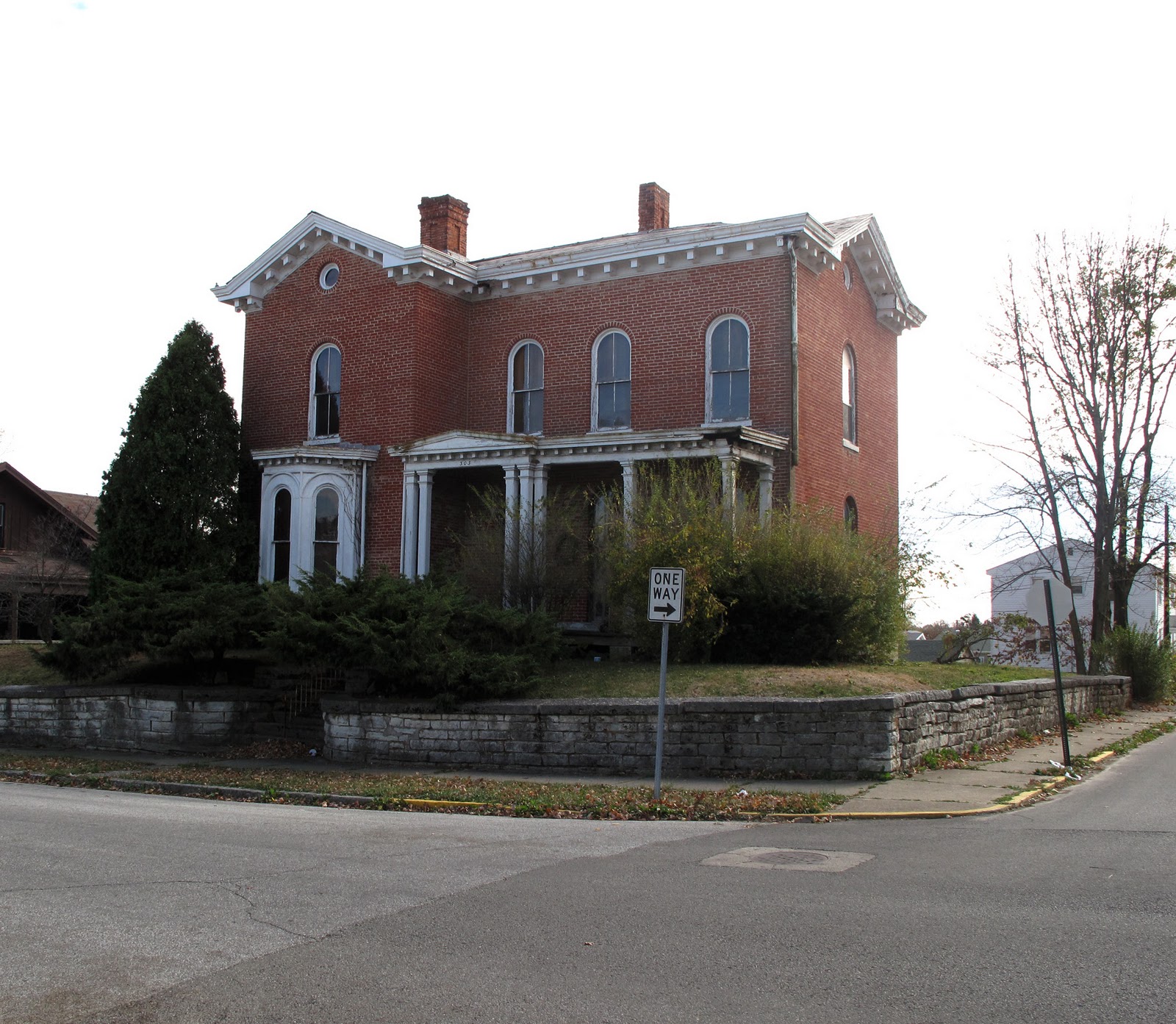
And got lucky. Here it is. The Grover house, in the 300 bock of Central Avenue, in 2010.

The three windows over the porch and the stone wall in front of the house clinched the ID. Once considered so impressive that someone sketched it and turned its image into a lithograph to represent the county's finest homes, this house now looks to be abandoned. That's some fine architecture going to ruin.
The other home we looked for was one of a multitude of Italianate farm houses constructed throughout the county in the 1870s. It would be a fascinating research project to see who the brick masons were who designed and constructed all these homes. Some are doppelgangers of their neighbors' or other homes just down the road. That happened to be the case here.
Here's the 1882 atlas of the John E. Robbins farm. See the gable of the barn facing the road off to the right? Notice the stone wall in front?
There are two houses in adjoining farms that match the design of the house in this litho. I'm not certain which is the right one.
The house below has new rectangular windows but the original arched openings are still visible, bricked in around the new windows. People, you shouldn't do that. Yuck. But even with these changes, you can see it's very similar to the, perhaps the very same, house in the litho.
And, lookee, next to the road, just to the north of this house (and not too far south of the one below), is the stone wall shown in the lithograph.
But wait. Just north of this house is its doppelganger. This second house is still in the Robbins family. Unfortunately, the trees are so thick you can't see the house well behind them in this photo. On the ground, I could see that the Gabled-Ell plan matched the one in the picture, and I could see the round oculus window under the gable, and the same brackets under the gable as shown in the house in the litho. The porch is the same configuration as the litho porch. AND, although it's nearly impossible to see through the trees, there is a board-and-batten barn behind the house to the right in exactly the same location and with the same windows as the one in the litho above.
So, which of these is the house?
Take a look at the front yard landscapes of both of these farmsteads, too. See the remnants of the plan shown in the lithograph? Although none of the trees in the two rows in front of the houses are old trees, both lawns show evidence that there was an allee of trees in the front lawn, later owners replanted trees where the original ones had been. Both of these farmsteads retain this landscape feature straight out of an Andrew Jackson Downing book.
I know one of these houses is the match. In my opinion, judging from the set back from the road, the curve in the road in front of the property, and the board-and-batten barn, and the fact that it's currently a Robbins family property, I think the second one is the Robbins farm shown in the lithograph. But since the first house also matches the one in the lithograph, and there's a portion of stone wall right next to the property, could be this is the one... Hm.
Final bit of analysis is the Atlas map. Not much help, it shows two houses [gray squares] on J. E. Robbins property along the Greensburg Sand Creek Toll Pike. And, by the way, the "school" noted on the map just south of the Robbins farm is still there, too.
Which one is the one in the litho, then? What do you think?

 Below is the same house in a photo taken from the east and looking west across the highway.
  And below is an etching of this house from the 1882 Decatur County Atlas.
  You can see that the tower is now missing, but the rest of the house is pretty much intact, though several windows are boarded up and there are roof issues that will wear this beauty down fast. This would be a fabulously rewarding fixer-upper project for someone.